
Soil Taxonomy
Shelby County, Indiana lists about 30 different soil types. Each soil presents unique challenges and growing conditions for the crops grown. The four most common soils of the county in order are Crosby, Brookston, Miami, and Westland Clay . Those four soil types make up roughly 65% of all soils in this county. Soils are classified based the forming factors and the soil horizons . There are five factors that distinguish soil types. These are parent materials, climate, topography, biological materials, and time. These five factors can be used to predict certain soil types and where they can be found. Soil types are broken into taxonomic series based on the color, structure, texture, and other properties to two meters (6.5 feet) of depth.
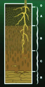 As soils develop over time, they establish layers called “ horizons
”. With the right soil forming conditions, up to six different horizons can be produced. Each of these horizons has specific subcategories that allow us to classify each soil. These master horizons are the O, A, E, B, C, and R. The O Horizon
is only found in undisturbed soils. It is made up of decaying vegetation and is usually quite dark because of the buildup of humus. The next horizon below the O horizon will be the A Horizon
. This is the surface of our cropland and is usually the most productive layer of our soils. This layer contains the most root activity, partly due to the nutrients held. Below the A horizons, an
E Horizon
can sometimes be formed. This layer is leached of nutrients leaving behind mostly sand or silt. It is characterized by a bleached appearance. This usually appears in soils formed under forests.
As soils develop over time, they establish layers called “ horizons
”. With the right soil forming conditions, up to six different horizons can be produced. Each of these horizons has specific subcategories that allow us to classify each soil. These master horizons are the O, A, E, B, C, and R. The O Horizon
is only found in undisturbed soils. It is made up of decaying vegetation and is usually quite dark because of the buildup of humus. The next horizon below the O horizon will be the A Horizon
. This is the surface of our cropland and is usually the most productive layer of our soils. This layer contains the most root activity, partly due to the nutrients held. Below the A horizons, an
E Horizon
can sometimes be formed. This layer is leached of nutrients leaving behind mostly sand or silt. It is characterized by a bleached appearance. This usually appears in soils formed under forests.
The next horizon will be the B Horizon or subsurface horizon. This layer is usually denser and has less nutrients and organic matter than the A horizon. Much of the materials such as clays, accumulate in this zone after leaching from above. The type of accumulation in the horizon will be classified by a corresponding letter following the B. Below the B horizon is the C Horizon . The substrate horizon usually consists of less clay than the horizons above or it might be made up of partially disintegrated parent material. Finally, below the C horizon is bedrock or the R Horizon . Bedrock can be very shallow or very deep. With only the upper 2 meters being used to define a soil series, soils with deeper bedrock layers do not describe an R horizon.
Example of Soils using those from Shelby County, Indiana
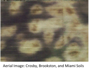
| Aerial Image: Crosby, Brookston, and Miami Soils |
Crosby soils are the most common soils in our area making up roughly 33% of all acres in the county. These soils are somewhat poorly drained and were formed by glacial till and thin layers of loess. Loess is a wind deposited sediment that is usually yellowish gray in color. The native vegetation of this soil was hardwood forests. The slope on this soil can vary from 0-6% and will be noted as CrA for 0-2, CrB for 2-4, and CsB for 4-6%. The soil is naturally low on organic matter and is usually most limited by excessive moisture. A typical Crosby soil will have a Ap horizon followed by an A2 at 8 inches. An Ap layer is a plow layer in the soil from continuous tillage. Following the A2 layer there will be a B layer starting at around 11 inches and ending around 34 inches, where we hit the R horizon or bedrock.
 The Brookston
soil is the next most common soil and makes up roughly 16.5% of all soils in the county. These very poorly drained soils were formed in the drainage ways of glacial tilled soils. They are typically located on 0-2% slopes. They have naturally high organic matter and are usually limited by excessive moisture. The native vegetation of the soils are hardwoods, grasses, and sedges. The A layer is typically 0-9 inches deep followed by the A12 typically 9-16 inches. The B layer extends down to 44 inches followed by the C Horizon. When properly drained these soils are highly productive.
The Brookston
soil is the next most common soil and makes up roughly 16.5% of all soils in the county. These very poorly drained soils were formed in the drainage ways of glacial tilled soils. They are typically located on 0-2% slopes. They have naturally high organic matter and are usually limited by excessive moisture. The native vegetation of the soils are hardwoods, grasses, and sedges. The A layer is typically 0-9 inches deep followed by the A12 typically 9-16 inches. The B layer extends down to 44 inches followed by the C Horizon. When properly drained these soils are highly productive.
The Miami soils are typically some of our least productive soils in the county. They are highly erodible but are better drained than the Crosby and Brookston soils. They typically form on slopes and ridges throughout our county. The native vegetation of these soils are hardwoods. The main area of concern on these soils is erosion. Be careful of tillage on these soils as they erode and wash easily. The slopes on these soils can vary from 2-18%. There are seven different subcategories of Miami across the county. These categories are based on clay, silt, sand, slope of the soil. For more information on these subcategories check out the Shelby county soil survey or the web soil survey linked in the “Resources”. Miami soils typically have an Ap layer 0-6 inches. Next the B horizon from 6-40 inches. Below that is the C horizon typically down to 70 inches.
Westland Clay is a very poorly drained soil that is typically found in the southern part of the county. They are made up of a loamy outwash over a loose sand and gravel. They are typically found in depressed areas of the field. And are usually found with Sleeth soils. The native vegetation is water resistant hardwoods, grasses, and sedges. Organic matter in this soil is high and if properly drained can be made very productive. This soil is usually limited by its high-water holding capacity and its typical flooding. This soil is usually on a slope of 0-2%. The Ap layer is typically 0-7 inches followed by an A12 layer from 7-13 inches. The B horizon typically has sub horizons from 13-45 inches. The C horizon is typically found at 45 inches. These soils are very level and do not drain well so they will usually require tile or surface drainage to be productive.
If you have questions about soils on your farm or want to take a more in depth look at the information provided here, check the resource section below. We are happy to help with any questions you might have. We have many different soil types in the area with different carrying capacities for crops. These soil differences are the major reason variable rate applications are a best management practice. It helps to know the background to get the full picture of our land.
Resources
- Shelby County Soil Survey
- Web Soil Survey
- From the Surface Down
The post appeared first on Greene Crop Consulting.